You have got JavaScript turned off. Many features of this website may not work. Please turn JavaScript on for an optimal experience.
Toggle navigation
Providers
Courses
Workshops
Shop
Contact
Sign-Up
Log in
Barry Thomas
- 157484
logs
1,402
Awards Completed
MLW
MCI
FCA
CWIA
RCI
CWDI
ML
CWI
Member Of
Details
Records
Photos
Schemes
CPD
Files
Referees
Back to List
Walking Record
My DLOG
Details
Date :
22/04/2018
Duration :
3-5 hours
Style :
Leader / Supervisor
Type :
Hill/Moorland Walking
Weather :
Overcast
Wind :
No wind
Camping Type :
N/A
Nights Camping :
0
Mountains :
Flagged :
Description
Night Navigation Course with up to 6 clients
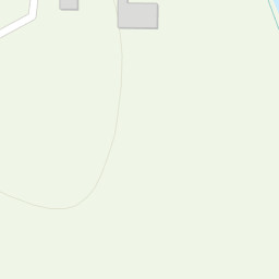
From Sharpitor Car Park up towards Leedon Tor and down towards river and settlements before heading back round via various micro features.
Area :
Dartmoor
The North and South Moor
Location
+
−
Leaflet
|
Tiles © Esri — Esri, DeLorme, NAVTEQ, TomTom, Intermap, iPC, USGS, FAO, NPS, NRCAN, GeoBase, Kadaster NL, Ordnance Survey, Esri Japan, METI, Esri China (Hong Kong), and the GIS User Community
OS Maps are only available to premium members. Click
here
to learn about premium accounts.
×
Confirm
Are you sure?
Loading
×
We use cookies to make sure that we give you the best experience possible on our website. Without cookies this website would not function properly.
To understand more about cookies please click here


 Night Navigation Course with up to 6 clients