The Irish Mountaineering club organised a meet in Donegal to climb at Lough Belshade. The weather forecast looked grim and I suggested that the group, which included new members and novice climbers bring hiking gear so we could get something done.
Friday was fine except for rain at lunchtime which cleared to showers and then sun shine by 5.
We got some routes done. On the way in and out to the crag I was chatting to my climbing partner how we might navigate in and out in bad weather. She has good hiking experience, ski tours and leads HS-VS, but she has little navigation experience. We started identifying features and naming them, things like boulders that looked like chairs, large steps etc.
The next day all this was useful.
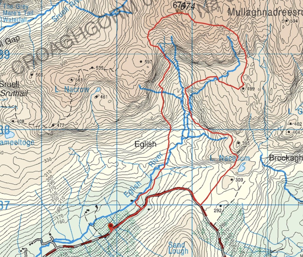
Saturday was wet, despite the optimism of some of the late arrivals it was not going to clear. I offered to lead a hike into the valley to show them the crags. None of them had been there before, so my climbing partner from the previous day got to do some navigation on the way in and out trying to find the route we walked on Friday. It was a great little exercise for her and she got most of it except for the choice to descent into the valley to the base of the first crag. She missed the little gully we descended the day before because she aimed to high and crossed above it. I let her continue for a while until I pointed out very steep ground on our left. Had we passed that yesterday? The group were happy with the leading and happy to wait till she began to work it all out. Had we descended yet? Have we lost height since crossing the summit? Where is this steep ground on the map? where is our gully? Everyone pitched in with some really good observations and it was full of good banter despite the very wet weather and 10 meter visibility at times. She decided she had contoured around the edge of the valley and had not descended the valley enough. What would she expect to find if she continued on her chosen route. The descent route we had used yesterday to get off the crag and then a stream running from the edge of the crag. She was right, happy out when we arrived at the first crag. We went on like that as we progressed along the valley trying to find each crag, group members really got into it even comparing guidebook photos with huge patched of lichen on the crag to position ourselves. We did our circuit using steams and level terraces and a bit of pacing and estimated times until we got to the back of the valley, we then climbed to the summit, point 674m, where we had a little chat about how to get down in what was now very poor visibility. There was very little wind and I was happy with the ability of the group regarding walking and equipment so I was happy to find an alternative route down and have a look at the final crag at the extremity of the valley called “The Outpost”. We planned a route to find a col SW of the summit and then turn South then East to intersect a stream which we followed steeply down over steps to a large terrace under the crag, point 597m was directly above us at this point. From here we decided to cross the valley floor and handrail a stream instead of climbing up again and returning by the same route.
The stream was a good escape route requiring little navigation except to mind our footing. We turned from the stream when we cane insight of a derelict house (shown in the guide book photos) and the edge of a forest. From there we hit the road and returned to our cottage base to dinner preparedly the club members who didn’t go on the hike.
I’d rather be hiking than cooking,. I had a great day and really enjoyed the instruction and teaching part and to be out with a group that were engaged with what they were doing despite the conditions.
Area :
Bluestack Mountains