Mia Walker - 1428254
logs 211Awards Completed
 ML
ML
ML
ML
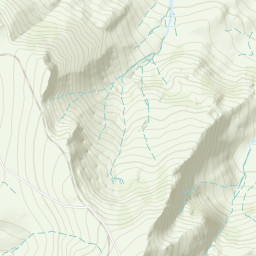
The Glyderau (a Welsh plural form, also known in English as the Glyders) are a mountain group in Snowdonia, North Wales. The name derives from the highest peaks in the range, Glyder Fawr and Glyder Fach. According to Sir Ifor Williams, the word "Glyder" derives from the Welsh word "Cludair", meaning a heap of stones.
 Glyder Fawr & Glyder Fach from Pen y Gwryd with 3 friends. Up new track to Pen y Pass, red dot route up the Glyder Fawr ridgeline, descent from Glyder Fach via old miners track to the A4086 layby. Unexpected chance to use my ML skills even though I wasn't the leader: one group member panicked and froze on the slabby final ascent to Glyder Fach. I scrambled back down to her, calmed her down, talked her through where to put her feet, held out my poles to give her something to hold on to, and got her across. Once she was across, she was in a bit of shock so I had her sit down, gave her an energy bar, asked her to hydrate, and reassured her that we all have bad moments in the hills because she was quite down on herself for having been afraid. Later on another group member had leg cramp and I gave him a chewable electrolyte, which helped him recover and carry on. Quite a day!!