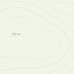
Last day of walking before my ML assessment. Wanted a shorter walk today to try and ease the stiffness and soreess from my legs. I also have blisters all over my heels on both feet. I spent a good deal of time today working on fine tunning my timings and pacing. Trying to work out exactly how much time eah contour line takes to add on to my timing calculations. I think I finally got a bit more of a understanding of it. Siabod is a really cool mountain. Through forest at the bottom, boggy the further up you go and then rocky on top quite a mixed bag. The view from the trig point today was pretty awesome even though the wind was horrible. Was nice to finish up on this before Monday.
Area :
Rhinogydd
The Rhinogydd (a Welsh plural form, often anglicised as Rhinogs and also known by the alternative Welsh plural Rhinogau) are a range of mountains located east of Harlech in North Wales. The name Rhinogydd derives from the names of two of the more famous peaks, Rhinog Fawr and Rhinog Fach, although the greatest elevation in the range is reached by Y Llethr, 756 m.