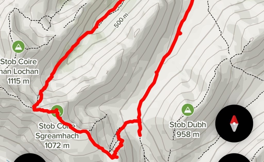
WQMD - Stob Coire Sgreemhach & Lost Valley Circular
Co-Ordinate locations.
1. NN1877856203 - Car Park on A82 - cloud was low and visibility was poor.
2. NN1700553415 - follow valley for 4km Lairig Eilde, as soo as the ground falls away then head SW to the base of the first summit of Stob Coire Nan Easan - 708m - NN1657552728.
3. NN1657552728 - steep ground ascent. Some scree accounted and I demonstrated the technique to cross and ascend without losing ground. From approximately 600m there was plenty of snow sections to practice cutting edges and kicking steps. On reaching the summit of Stob Coire Nan Easan we then headed NW descending a short section and then re-ascending to Stob Coire Sgreemhach.
4. NN1547953638 - The ascent to SCS required us to ascend plenty of snow sections. At this point i was able to discuss the dangers of cornices and showed where you could see the cornice breaking away. We walked through the clouds from poor visibility through our journey so far, to have an awesome clear view of the surrounding areas as we reached the summit.
5. NN1505653668 - At Bealach Dearg we was our descent point. This section necessitated crampons and ice-axes due to the amount of snow and gradient. Probably grade one - steep snow descent although nothing too difficult. I demonstrated and we practiced axe arrests with my son.
6. We continued down into the lost valley which was awesome.
7. NN16677655621 - we entered a ver dank wooded area past a large rock that could of been from a set of Jurassic Park..! The snow cleared when we reached the valley floor and it was strange that Allt Coire Gabhail seemed to disappear only to reappear as waterfalls as we entered the weary dank wood. This was incredible and I loved this section. The light was disappearing as we descended this section
8. NN1732056360 - we joined the “meeting of three rivers” and crossed the footbridge. From here we joined the A82 and headed up the Caledonian Way for a short stretch before heading off back to the CarPark. On returning to the car we had already donned our head torches.
1 • Ascent of a significant mountain is included in the day;
Yes - 1072 M altitude of Stob Coire Sgreemhach.
2 • Individual takes part in the planning and leadership;
Planned the route using OS Maps and OS online and AllTrails… Basic route plan worked out to calculate distance and time for each leg.
Also, viewed Routes on YouTube and internet for descriptions of Route. And looked at Google Maps to see what the terrain looked like.
Lead throughout and made all the decisions that were necessary.
3 • navigation skills are required;
Yes - the 4km mark was a learning point - going a little further than planned and began descending into Coire Nan Essan - this was mainly due to the very poor visibility. This was a good learning point for me as I knew something was not right as we had began to descend (a catchment for me), so we returned and then contoured around to the base of the first summit. From there on the navigation was reasonably straight forward - just kept an eye on the ground to the map as we ascended.
4 • knowledge is increased and skills practised;
We covered :
kicking in, edging, and step cutting.
Cramponing and Ice axe techniques.
We practised safe and efficient movement over the snow covered terrain.
Covered steep ground ascent with crampons and safely crossing scree.
5 • attention is paid to safety;
Checked weather forecast before heading out… Checked Avalanche reports for area. MWIS weather report. And Face Book ground conditions. Also checked Winter Climbing Forecast (app). First Aid Kit and Shelter along with a confidence rope were carried. Discussed the dangers of snow cornices - in many places the cornices were showing evidence of breaking away.
6 • adverse weather and underfoot conditions may be encountered;
Yes, Neve / snow / Ice at higher levels over 600m.
Visibility was changeable throughout the journey from 20m’s to being clear. At higher levels over 1000m the temperature dropped below zero. We were rewarded with clear views above the clouds when we summited Stob Coire Sgreemhach - see photo.
7 • Five hours or more journey time;
Yes this journey was over 7 hours of mountaineering it a great WQMD.
Area :
Glencoe South (Loch Linnhe To Loch Etive)
The southern side of Glen Coe includes some very well-known mountains and can be split into two groups; the ones you can see from the A82 and the ones you can’t. Included in the former group is Buachaille Etive Mor, Buachaille Etive Beag, the Three Sisters and the Ballachulish Horseshoe, and in the latter, three Munros between Glen Creran and Glen Etive (Sgor na h-Ulaidh, Beinn Fhionnlaidh and Beinn Sgulaird). With huge amounts of climbing and walking in summer and winter, this area is also home to a large cairn built for Queen Victoria, or so the story goes. Includes all major peaks above 600m.
 ML
ML